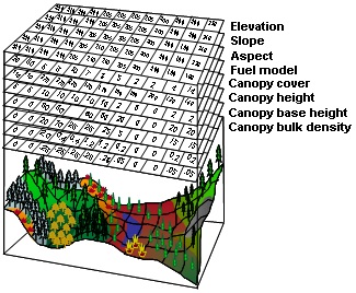
Running FlamMap or FARSITE, two commonly used fire behavior modeling programs, requires a landscape file (LCP). LCPs are binary files containing a compilation or “sandwich” of ASCII data, including elevation, slope, aspect, fuel model, canopy cover, canopy height, canopy base height, and canopy bulk density.

Landscape file (LCP) schematic, adapted from Finney (2006).
In addition to the eight layers listed above, a FlamMap or FARSITE LCP can include duff loading and course woody fuels layer, but these are not easily obtained or often used. The Wildland Fire Assessment Tool (WFAT) also uses an LCP file with additional data requirements (fuel loading model and tree list data) for the fire-effects functionality.
ArcFuels10 streamlines the process of building LCPs from FVS/FFE-FVS output database(s), an attributed shapefile, or raster data. ArcFuels10 has the ability to reduce the analysis area based on another raster’s extent or coordinates, quickly apply treatments, and export ASCIIs and rasters created along with the LCP.

The Build LCP menu has a drop-down list with four options and seven accompanying exercises:
Build LCP Using FVS or GNN Data
Build LCP Using Shapefile Data
To start with the first form go to Build LCP Using FVS or GNN Data.